

Pak Sahafat – Expert studies show that the earthquake in Turkey this month was caused by a fault at a shallow depth of a nearly vertical left-handed fault with a northwest-southeast direction, or an almost vertical right-handed fault with a southwest-northeast direction.
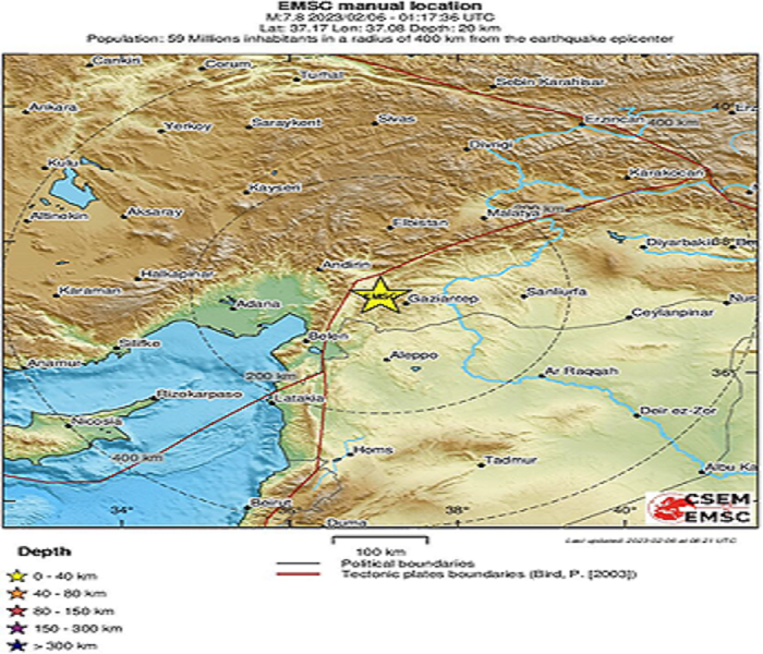
According to Pak Sahafat News Agency’s report, the International Research Institute of Seismology and Earthquake Engineering explained the characteristics of the February 6th earthquake in Turkey by four experts of this research institute. According to this report, an earthquake with a magnitude of 7.8 on the torque wave scale occurred at 17:04 local time, 30 kilometers west, northwest of the city of Ghaziantip, near the border of Turkey and Syria.
Characteristics of earthquakes with a magnitude greater than 7 days, 17th of Bahman
The US Geological Survey located the epicenter of this earthquake at the coordinates of 37.17 degrees north latitude and 37.03 degrees east longitude and its depth of 18 km, and the European-Mediterranean Seismological Center located the epicenter of this earthquake at the coordinates of 37.17 degrees north latitude and 37.8 eastern longitude and depth have been reported as 20 kilometers.
Until the preparation of this report (two days after the earthquake), about 320 aftershocks with magnitudes between 5.2 and 7.5 have been recorded in the region, 15 of which had magnitudes equal to and greater than 5. The largest of these earthquakes is a magnitude 7.5 earthquake on the torque wave (MW) scale, which itself was a new event.
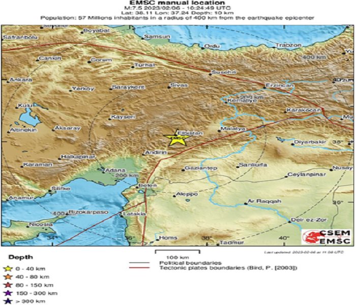
The characteristics of this earthquake are as follows; This earthquake occurred at 24:13 local time with a magnitude of 7.5 on the torque wave (MW) scale, 11 kilometers south, southeast of Al-Bistan city in Gahraman Mersh province.
The US Geological Survey located the epicenter of this earthquake at the coordinates of 38.02 degrees north latitude and 37.20 degrees east longitude and its depth of 10 km, and the European-Mediterranean Seismological Center located the epicenter of this earthquake at the coordinates of 38.11 degrees north latitude and 37.24 Its eastern length and depth have been reported as 10 kilometers. This earthquake occurred 105 km north of the earth.
Seismic history of the region
Initial reports showed that these earthquakes were felt in Turkey, Syria, Lebanon, Palestine, Iraq, Jordan, Egypt, Saudi Arabia and parts of Ukraine and Europe including Greece and Bulgaria. The number of casualties and injured in these earthquakes has reached more than 41,000 people by the time of writing this report, these earthquakes caused damage to historical structures in Turkey and Syria, and according to witnesses, the duration of the first earthquake was about one minute.
The first earthquake of magnitude 7.8 in southern Turkey near its northern border with Syria was accompanied by an aftershock 11 minutes later, the 7.8 earthquake was caused by the Rastalghaz fault at a shallow depth. This event was caused by an almost vertical left-handed fault with the northwest-southeast direction, or an almost vertical right-handed fault with the southwest-northeast direction. The initial location of this earthquake was in the vicinity of a triple junction between the Anatolian, Arabian and African plates. The mechanism and location of this earthquake is consistent with the earthquake that occurred in the Eastern Anatolian fault zone or the Dead Sea transform fault zone.
The area where the first earthquake occurred is seismically active. Since 1970, three earthquakes with a magnitude of 6 or more have occurred within a radius of 250 km. All three of these earthquakes occurred along or near the Eastern Anatolian fault. Despite the relative seismicity of the epicenter region in the past, Aleppo in Syria has been devastated by large earthquakes several times throughout history, but the exact location and magnitude of these earthquakes are only estimated. It is estimated that an earthquake of magnitude 7.1 destroyed Aleppo in 1138, and another devastating earthquake of estimated magnitude 7 occurred in 1822. The casualties of the 1822 earthquake are estimated to be around 20,000 to 60,000 people.
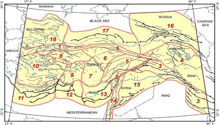
The tectonics of Turkey and adjacent areas/the speed of the Arabian plate causes the left-lateral movement of the latitudinal strike
At least 4 tectonic plates including the Arabian plate, Eurasia, India and Africa and a smaller tectonic block (Anatolia) are responsible for seismicity in the Middle East and surrounding areas. The geological evolution of the region is the result of a number of first-order plate tectonic processes, which include subduction, large-scale transform faulting, orogenic compressional movement, and crustal stretching.
The African, Arabian and Eurasian plates have a complex interaction in the eastern margin of the Mediterranean region. The rift (a linear region where the Earth’s crust and lithosphere diverge and is an example of extensional tectonics) of the Red Sea is a spreading axis between the African and Arabian plates, with a rate of divergence in the north of about 10 mm per year and at the southern end close to 16 mm per year. The rate of seismicity and the size of earthquakes in this opening axis are relatively small, but the Kaft process has created a series of volcanic systems in eastern Saudi Arabia.
In the north of the Red Sea, Kaft ends at the southern border of the Dead Sea Transform Fault. The Dead Sea transform fault is the Rastalghazi fault, which compensates for the differential movement between the African and Arabian plates. Although the African plate in the east and the Arabian plate in the west are moving in the direction of the north and northwest, the speed of the Arabian plate is slightly higher, which causes a left-handed movement in this part of the plate boundary.
Historical seismic activity along the Dead Sea transform fault is an important natural hazard for the dense population living in the Levant region (Eastern Mediterranean) and for example, it is estimated that the November 1759 earthquake in the Near East killed between 2 and 20 thousand people. . The northern terminus of the Dead Sea Transform Fault is located in the complex tectonic region of southwestern Turkey. In this place, the African and Arabian plates and the Anatolian block interact. This interaction involves westward translational movement of the Anatolian Block at a rate of approximately 25 mm/yr relative to Eurasia, which compensates for the closure of the Mediterranean Basin.

The North Anatolian right-striking fault in northern Turkey offsets most of the eastward movement between the Anatolian Block and the Eurasian Plate. A series of devastating strike-slip earthquakes with a magnitude greater than 7 between 1939 and 1999 extended eastward along the North Anatolian fault system. The easternmost of these earthquakes was the August 17, 1999 earthquake with a magnitude of 7.6 in Izmit, Turkey, near the Sea of Marmara, which killed about 17,000 people.
The western-eastern arc of Cyprus is also located on the southern edge of the Anatolian block with moderate seismicity. The Cyprus arc represents the convergent boundary between the Anatolian block in the north and the African plate in the south. It is thought that this border in the east of Turkey joins the Eastern Anatolian fault zone, although it is not possible to state the exact and single relative movement direction for the entire length of this tectonic border.